The inclination to the north-south axis means that these satellites do not go directly over the poles. But they pass close enough to provide true global coverage from a single satellite.
As far as the instruments we are considering here are concerned, while the satellite is following its near-polar orbit the spectrometer scans the surface from side to side, that is, 'across track'. The resulting area of the Earth that is imaged during the satellite orbit is known as the swath.
The width of the swath depends on the characteristics of the instruments used. The GOME instrument on ERS-2 and the SCIAMACHY instrument on ENVISAT (in nadir mode, that is, looking downwards) both have a swath width that can extend up to 960 km. Because of the movement of the satellite in its orbit and the rotation of the Earth beneath it the track of the swath on the surface describes a north-south path skewed from east to west.
Here is figure showing the measurement of slant column densities for NO2 during a pass of the SCIAMACHY instrument on the ENVISAT satellite over Bremen (53° N). This figure shows the 960 km wide swath of the downward-looking nadir scans of the SCIAMACHY instrument. The seeming change of width of the swath results from the distortion of the map projection onto a plane surface. The gaps in the swath are caused by the alternating limb scans that SCIAMACHY makes.
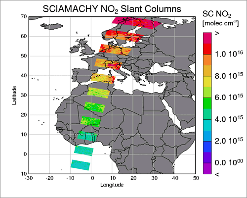
Fig 1.2.1.3.1: The SCIAMACHY nadir scanning swath
Image: AT2-ELS