In nadir mode the spectrometer looks more or less directly down from the satellite to the Earth. Measurements are received from the column of atmosphere under the instrument.
Nadir mode measurements record the earthshine, that is the solar light that is scattered by the atmosphere and/or scattered or reflected from the surface. They are performed during the dayside transit of each orbit.
The satellite carrying the instrument is in a sun-synchronous, near-polar orbit approximately 800 km above the Earth that takes about 100 minutes. On the dayside part of its orbit it is travelling north to south. The rotation of the Earth relative to the orbit of the satellite causes the path of the satellite to track east to west over the surface of the Earth. The instrument covers the entire surface of the Earth every three days.
As it passes over the Earth's surface the nadir mirror of the spectrometer scans across the track of the satellite.
Each scan covers an area on the ground of approximately 40 km along the track by a maximum of 960 km across the track.
GOME nadir scan characteristics
| Scan data | Max. width: Height: Sweep duration: Direction: |
960 km 40 km 4.5 s East to west |
|
| IFV* | Width: Height: |
2 km 40 km |
|
| Ground pixels | Pixels per forward scan: | 3 | |
| Pixel data | Width: Height: Scan duration: |
320 km 40 km 1.5 s |
|
| Backscan | Width: Height: Sweep duration: Direction: |
960 km 40 km 1.5 s West to east |
*IFV = Instantaneous Field of View
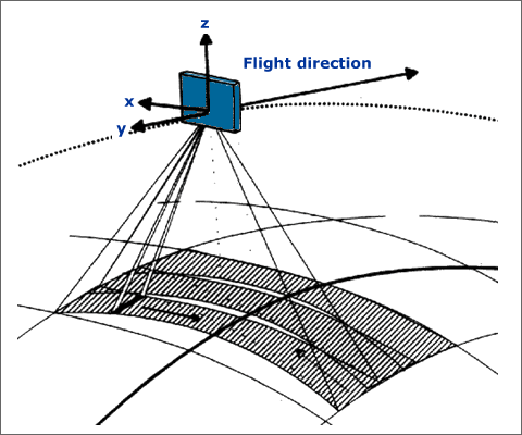
Fig 1.3.1.1.1: Nadir mode scanning geometry
Image courtesy of IUP Bremen
In addition to nadir mode measurements the GOME scan mirror allows solar and polar viewing, as well as lunar observations at certain times during the year.