In nadir mode the instrument looks more or less directly down from the satellite to the Earth. Measurements are received from the column of atmosphere under the instrument. Nadir measurements record the solar light scattered by the atmosphere and from the surface and are performed during the dayside transit of each orbit.
The satellite carrying SCIAMACHY is in a sun-synchronous, near-polar orbit approximately 800 km above the Earth that takes about 100 minutes. The rotation of the Earth relative to the orbit of the satellite causes the path of the satellite to track east to west over the surface of the Earth.
As it passes over the Earth's surface the nadir mirror of the spectroscope scans across the track of the satellite. Each scan covers an area on the ground of approximately 30 km along the track by 960 km across the track, at a typical resolution of 30 km by 60 km. In nadir mode an across track scan lasts 4 s, followed by a fast 1 s backscan. This pattern is repeated for a total duration of either 65 or 80 s, depending on the orbital region. The nominal swath size is 960 km, but a smaller swath size of 120 km can also be selected.
SCIAMACHY nadir scan characteristics
| Scan data |
|
Max. width: Height: Sweep duration: Direction: |
960 km 30 km 4 s East to west |
| IFV* |
|
Width: Height: |
2 km 30 km |
| Ground pixels |
|
Pixels per scan: | 16 |
| Pixel data |
|
Width: Height: Scan duration: |
60 km 30 km 0.25 s |
| Backscan |
|
Width: Height: Sweep duration: Direction: |
960 km 30 km 1 s West to east |
*IFV = Instantaneous Field of View
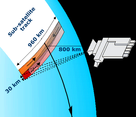
Fig 1.3.2.1.1.1: Nadir mode scanning geometry of the SCIAMACHY instrument.
Image courtesy of :
When scanning in dedicated nadir mode the instrument covers the entire surface of the Earth every three days.