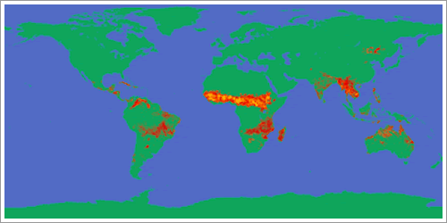
Fig 1.1.6.4.1: Global distribution of fires.
Image: NASA Earth Observatory
The map shows fire distribution worldwide. Fires are represented by red orange, and yellow dots (lighter colors indicate more fires). The image is based on night-time measurements obtained by the DMSP Operational Linescan System.
Africa is the principal location for biomass burning, with more biomass burned on an annual basis than anywhere else.
In Africa, biomass burning takes place at two principal times of the year, corresponding to the dry season of each hemisphere. December to March (with a maximum in January-February) above the equator and June to November (with a maximum in September-October) below the equator.

Fig 1.1.6.4.2: Smoke plumes over South America photographed from the Space Shuttle, 1994.
Image: NASA STS065-85-001