In nadir mode the spectrometer on board the satellite is aligned towards a ground pixel and measures the spectrum of the radiance in that direction.
The entire optical path returned in the line of sight from a ground pixel in the course of a nadir mode scan can be represented in a simplified two-dimensional form as follows.
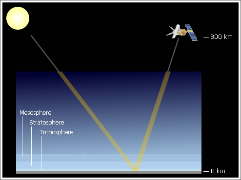
Fig 3.4.1.2.1: The total slant column in the atmosphere
Image: AT2-ELS
This diagram contains two significant graphical simplifications:
- In practice, the angle of the sun to the normal at the pixel on the surface — the solar zenith angle, SZA — varies dramatically with the position of the satellite as it travels north to south in the dayside section of its orbit. The first pixel observed on the dayside is illuminated by sunlight at a low elevation angle from the southeast for GOME and SCIAMACHY. The elevation of the sun increases for each subsequent pixel up to a maximum noon angle in the east, and then descends finally to a low elevation angle in the northeast for GOME and SCIAMACHY.
- The angle of the line of sight of the satellite to the normal at the ground pixel also varies with the angle of the scan across the track of the satellite.
As already noted, our principal interest in the remote sensing of NO2 is in the tropospheric layer of the atmosphere just above the surface of the earth, the relatively thin slice of atmosphere at the bottom of the diagram, on average ~8-15 km thick. It is the densest part of the atmosphere above the boundary layer at the surface, but represents only about 10% or less of the total atmospheric light path.