Stratospheric temperatures were on average warmer during spring 1998 than in the previous years and the polar vortex was rather weak and displaced most of the time towards Northern Europe and the North Atlantic. Low total ozone in northern polar latitudes can occur when upper-tropospheric anti-cyclonic systems move beneath the polar vortex lifting the tropopause. These synoptic-scale areas of strongly reduced total ozone are termed ozone mini-holes (Newman et al., 1988).
An ozone mini-hole event was observed by GOME over the Northern Atlantic on 12 March 1998 (top, Fig. 4). Subtropical air was advected to the North raising the tropopause, as indicated by the low PV (4-6 PVU) at 350 K in the Northern Atlantic region between the east coast of Greenland and the British isles (top, Fig. 4). Lifting of the tropopause causes the stratospheric air on the above lying isentropic levels to be lifted, which in turn leads to adiabatic cooling and low TOZ (McCormack et al., 1997). The correlation between low PV and low TOZ (Fig. 4) can clearly be seen.
The history of air masses at one subsatellite point of the GOME orbit (61 deg N, 40 deg E) on three isentropes 350 K (solid line), 475 K (dotted) and 675 K (dashed) is displayed in Fig. 5. The start time for the backwards trajectory is 12:00 UTC. Each circle stands for one day backwards. The lowermost air (350 K) is clearly identified coming from the subtropical region near 30 deg N. At 475 K the air is just outside of the vortex and remains close to the vortex edge, while at 675 K the air is inside the vortex. This effect can be seen in the lower panel of Fig. 4. A thinning of the ozone concentrations in the layers above 350K is clearly detectable in the GOME altitude-latitude chart near 60 deg (top, Fig. 4) and are responsible for the reduced TOZ (top, Fig. 4).
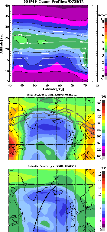
Figure 4: Top: Ozone
height distribution along the North Atlantic GOME. White contour
lines indicate the various potential temperature levels. Middle:
Potential vorticity in units of ![]() m-3 at
m-3 at ![]() 550K in Northern Europe derived from ECMWF analysis.
The latitude and longitude scales for both maps are ranging from 40 to
80 deg N and from 70 deg W to 20 deg E. The sub-satellite points of
the North atlantic GOME orbit is indicated by the dashed line.
Bottom: Total ozone field derived from the GOME Level-2 Version 3.0
data in the same region as shown in the middle plot. PV contour lines
in units of 36-48
550K in Northern Europe derived from ECMWF analysis.
The latitude and longitude scales for both maps are ranging from 40 to
80 deg N and from 70 deg W to 20 deg E. The sub-satellite points of
the North atlantic GOME orbit is indicated by the dashed line.
Bottom: Total ozone field derived from the GOME Level-2 Version 3.0
data in the same region as shown in the middle plot. PV contour lines
in units of 36-48 ![]() m-3 at
m-3 at ![]() 475K define the polar vortex edge.
475K define the polar vortex edge.
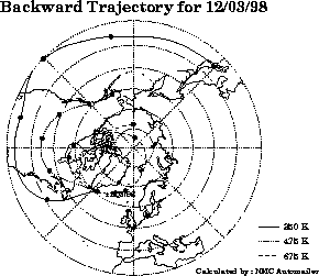
Figure5: Backward
trajectories of air masses at the potential temperature levels 350K,
475K and 675K (Data taken from NASA GSFC automailer).