Regional Applications
NORSAT - NutzerORientierte SATellitenbildanalyse
Hendrik Laue*, Ralf Schmidt
Funding: Senator für Bildung und
Wissenschaft; Programme "Arbeit und Umwelt"
Objective of the project is the extraction of information from satellite images of high spatial resolution (i.e. better than 30m) for non-scientific users. The physical analysis of satellite images is strongly influenced by the needs and demands of the users which are predomninately interested in usefull information and not in the data base itself or the methods how the information is extraced from these data. In order to obtain realistic requirements for the data analysis and method development two pilot users participate in the project, which covers two areas of activity. The first is the "Prielkantendetektion" (i.e. detection of waterlines in wadden flats) and the second is the "Obsterntevorhersage" (i.e. prediction of the harvest yield for orchards).
The first area of activity is concerned with the detection of the waterlines (i.e. the borderline between water covered areas and dry wadden flats) of the the drainage channels (german "Priele") in the wadden sea. These data are needed by the Department of Planning of the City of Cuxhaven which is responsible for the area survey and mapping of Cuxhavens wadden sea. The mapping is produced in order to ensure the safety of visitors and tourists in this very complex and rapidly changing area. Up to now these maps have been created from digitalized photographs taken by airborne conventional cameras. Each pixel of a waterline is marked by an operator by visual inspection with the mouse on the computer screen, which is a labourious and time consuming work. Thus the use of satellite images and the development of an almost automatic edge detection algorithm for waterlines would be a cost effective alternative. In this project edge detection algorithms for waterlines based on different image processing techniques have been developed for different types of satellite images, especially for panchromatic and synthetic aperture radar (SAR) images. An example for the results obtained by using an algorithm for panchromatic images is given in Fig. 1, which shows a drainage channel in the wadden sea of Cuxhaven. The automaticly detected edges are overlaid in yellow. Despite the fact that some gaps in the waterline remain and several "false" egdes on the wadden flats occur, about 80% of the waterline are detected. These data can help to reduce the manuall portion of the work, which has still to be done, considerably (at least down to 20% of the original effort).
The second area of activity is concerned with the extraction of information
from multispectral satellite images which can be usefull for the support
of harvest yield prediction for orchards. In a region near the City
of Hamburg/Germany, called "Altes Land", the farming is dominated by orchards
which
consist in more than 80% of the area of apple trees. A reliable prediction
of the harvest yields for these fruits is very important for the trading
organizations and for the farmers in order to optimize their stock capacities
and get an estimation of the expected price developement. But all existing
methods give predictions which can differ up to 100% from the finally obtained
harvest yield. Any information that could help to improve these predictions
would be very valuable. Because of the extension of the area only a few
spot-test are used which may not be representative for the whole region
the uncertainty of the prediction is further increased. Thus the use of
remote sensing data, especially satellite images can remedy the problem
of the generalization of point-like information for a large area. In a
first step in the project of the parameters which are usefull and extractable
from remote sensing data are identified. The problem is that most of the
commercially available multispectral satellites sensors povide only a few
very broadbanded spectral channels in the visible (VIS) and near infrared
(NIR). In order to achieve a better insight which parameters related to
the apple trees can be derived from these data and which useful information
can be extracted (e.g. strength of the blooming, health status of the trees,
stress factors like drought or diseases, frost damages, etc.) ground based
measurement with a hyperspectral scanner have been carried out. The results
of these spectral and spatial very high resolved data will help to develop
algorithms for the analsis of the satellite images.
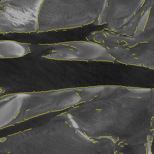
Fig. 1: Subimage of an IRS-1D PAN-scene taken at approximately
1 hour bevor low tide. The automatically detected edges are marked
in yellow. (For abetter view please open the jpeg-image in a separate
window.)

Fig. 2: Spectrum of sunlight reflected by an apple blossom. The bars illustrate the corresponding LANDSAT channels and their interpolated intensity.

Fig. 3: Example of data taken by an hyperspectral scanner. Clearly visible are the apple trees with white blossoms.
Teamwork
- Stadtplanungsamt Cuxhaven
- Erzeugergemeinschaft Elbe-Obst r.V.
- Obstbauversuchsring Jork e.V.
- airobotics GmbH
- R. Schmidt and, Laue, H., NutzerORentierte SATellitenbildanalyse - NORSAT, Institute of Environmental Physics, University of Bremen, Final Report, Bremen, 2001
(abstract of the report in german )
Inhalt: