Field of activity: Polar Surfaces
Synergy of active and passive microwave sensors for remote sensing of sea ice
Stefan Voß*, Georg Heygster
Funding: BMBF, EUMETSAT
Various satellite sensors are used for the exploration of the polar cryosphere. The Quickscat satellite launched in 1999 carries a Scatterometer. It emits radar beams to the earth surface (here: sea ice cover) and measures the backscattered signal which is normalized the the backscatter coefficient sigma-0. The power of the measured signal over sea ice depends on the roughness of the surface. First-year (FY) ice is usually flat and therefore the sensor measures low sigma-0 values. Multiyear (MY) ice has a weathered surface and includes pressure ridges and hummocks due to ice drift convergence. For this reasons MY ice produces high backscatter values. FY ice areas near the ice edge are influenced by low pressure systems with connected warm air during all the year, even in winter. This leads to melting and refreezing of the snow on top of the ice. The consequences are snow metamorphosis and formation of icy layers in the snow. The result are high sigma-0 values over FY ice similar to sigma-0 values over MY ice. The upper figure shows the sigma-0 values in the Southern Ocean. MY ice areas are in the Weddell Sea along the Antarctic Peninsula and along the coast around the Antarctic continent. All other regions are covered with FY ice. But there are large areas near the ice edge in the Indian Ocean sector and in the Ross Sea with high sigma-0. These are FY ice areas with a refreezing surface. An algorithm is developed which uses the different channels of the scatterometer to classify the ice types correctly. The result is presented in the lower figure. These results can improve the NASA Team ice type classification algorithm to have better input data for climate modelling.
Cooperations
Publications
- Voß, S., Will multiyear ice exist in the next century?, poster presented at the ERS Symposium 2000, Göteborg, 2000
- Voß, S., High backscatter areas over Antarctic sea ice observed with scattrometers; cause and detection, study performed under the framework of the Visiting Scientist Programme of Satellite Application Facility on Climate Monitoring of EUMETSAT, Darmstadt, 2000
- ANNUAL REPORT 2000
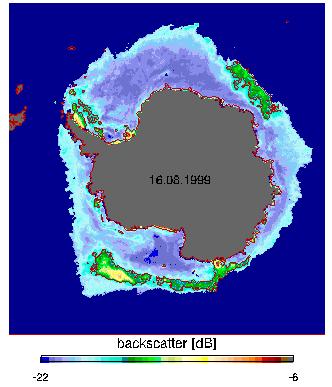
FIGURE 1: Backscatter values over Antarctic sea ice on 16th of August 1999 measured with the Quickscat-Scatterometer
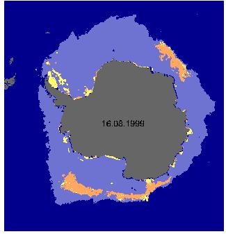
FIGURE 2: Sea ice classification with the new algorithm. Dark blue = Open ocean; Grey = Land; Pink = FY-ice; Yellow = MY-ice; Orange = FY-ice with icy snow layers due to refreezing events
Inhalt: