Methane Airborne MAPper (MaMAP): A new airborne 2 channel NIR-SWIR grating spectrometer system for simultaneous remote measurements of tropospheric methane (CH4), carbon dioxide (CO2) and oxygen (O2)
A joint research project of Institute of Environmental Physics / Remote Sensing (IUP/IFE), University of Bremen, Germany (K. Gerilowski, M. Buchwitz, H. Bovensmann, J. P. Burrows), Geoforschungszentrum Potsdam (GFZ), Potsdam, Germany (A. Tretner, J. Erzinger)
Methane airborne MAPper (MAMAP): A new airborne 2 channel NIR-SWIR grating spectrometer system for column-averaged methane and carbon dioxide observations from aircraft. A joint research project of the:
Institute of Environmental Physics / Remote Sensing (IUP/IFE), University of Bremen (Germany) and the
Helmholtz Centre Potsdam, German Research Centre for Geosciences (GFZ).
Scientific Objectives
Carbon dioxide (CO2) and methane (CH4) are the two most important anthropogenic greenhouse gases (GHG) contributing to climate change. In addition CH4 plays an important role in the chemistry cycle of the atmosphere.
Despite the importance of understanding the global atmospheric CH4 and CO2 budgets, our current knowledge about the sources (and sinks) of CH4 and CO2 has significant gaps. This arises in part because of the difficulty in estimating the highly spatially and temporally variable anthropogenic and natural atmospheric source emissions.
Up to now, flux estimates of CH4 and CO2 of current global, synoptic, and mesoscale 3-D chemical transport and climate models (CTM and CM) are based on either bottom-up or top-down approaches.
Bottom-up flux estimates of anthropogenic sources are typically compiled by national authorities by the assessments of economic statistical data or by emission factor estimates using a variety of procedures. For bottom-up flux estimates of natural sources, ground-based microscale measurements are collected from a variety of different techniques, such as closed chamber and eddy covariance methods. Emission and flux estimates obtained by these techniques are typically assigned to specific soil/vegetation types and then are spatially extrapolated to meso and synoptic scales using, for example, a global vegetation index, derived from satellite imaging data.
Top-down global, synoptic, and mesoscale emission estimates are based on precise and accurate atmospheric in-situ concentration measurements of the relevant gases from surface networks, tall towers, helicopters, aircrafts, and trains. These measurements are then inverted by inverse models to estimate flux rates between the surface and the atmosphere. Natural and anthropogenic bottom-up flux estimates are typically input into the inversion calculations. Based on the measured data the anthropogenic and natural fluxes are modified during the inversion calculation in a way that the simulated atmospheric concentrations better match the observations. As a result of the coarse density of the surface observation network, information about surface fluxes distant from the network is still not well defined and ambiguous. Especially discrimination of the different source types remains still inaccurate.
With the launch of the environmental satellites ENVISAT and GOSAT, with the SCIAMACHY and TANSO-FTS instruments on board new remote sensing data were incorporated for the first time to estimate the annual CH4 (and CO2) surface fluxes at a resolution of several degrees using top-down inverse modeling. Because SCIAMACHY’s and GOSAT's large typical footprints of 60 km × 30 km (for SCIAMACHY) and 10 km diameter (for GOSAT), and the large gaps between the typical measurements of GOSAT single local emissions cannot be accurately resolved in the currently available satellite data. Therefore the contribution of small “hot-spot” areas and single facilities is not sufficiently resolved with the existing ground-based and satellite observational systems.
To fill this gap, a team from the IUP Bremen and the GFZ designed and built an airborne remote sensing system, which is capable to detect surface sources of CH4 and CO2 at both local and regional resolution and coverage. The instrument is designed to measure the column averaged mixing ratio of methane (XCH4) and carbon dioxide (XCO2) with a total column relative accuracy and precision of equal or better than ~ 1% with respect to the atmospheric background.
MAMAP can not only deliver significant information on greenhouse gas emissions from localized sources like hard coal mines, large landfills, natural gas and oil production facilities, power plants, (mud) volcanoes, on- and offshore natural gas blowouts etc. but may also serve to validate and complement satellite measurements of current and future satellite missions, e.g. like the proposed greenhouse gas satellite mission CarbonSat (Bovensmann et al., 2010, http://www.iup.uni-bremen.de/carbonsat/ ).
The instrument is able to deliver quantitative column information, well suited for quantitative emission estimates based on inverse atmospheric modeling. Such data can be used for instance for quantification of accidental emissions with source strengths like reported by TOTAL for the ELGIN accident (see also here or for top-down estimates of the total emissions from large oil and gas production facilities and fields) or for top-down estimates of the total emissions from large oil and gas production facilities and and fields.
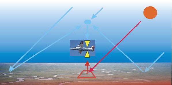
Based on our experience with SCIAMACHY, a two channel grating spectrometer system was developed. Similar as SCIAMACHY, the spectrometer covers important parts of the near infrared (NIR) / short wave infrared (SWIR) spectral region (around 1600 nm, 1660 nm and 760 nm) for CO2, CH4 and O2 measurements. The instrument has been designed for flexible operation on board of different airborne research platforms (e.g. DLR Dornier 228, DLR Falcon, Cessna Caravan, Cessna 207 and for the future DLR Gulfstream HALO aircraft).
Different laboratory, ground based and airborne measurements have been performed demonstrating the instruments performance.
The instrument is designed to measure the column averaged mixing ratio of CH4 and CO2 (i.e. XCH4 and XCO2) with a relative accuracy and precision of equal or better than ~1% with respect to the atmospheric background concentration (see also Gerilowski et al., 2011, Krings et al. 2011). Working in the SWIR spectral region (1.630 -1.675 µm for CH4 and 1.59-1.62 µm for CO2) the instrument has a high sensitivity for small changes in the boundary and surface layer CH4 and CO2 concentration.
At a flight altitude of 3 km and a ground speed of 300 km/h (DLR Do 228 aircraft), the co-added ground pixel size is in the order of 50 m (across track) x 100 m (along track) over land (surface albedo 0.18). Over water a similar pixel size (and precision) was achieved when the instrument is operated in Solar Glint-mode geometry. By reducing the dark current of the sensor head (sensor dark current + ambient thermal dark current) below 60 fA the instrument is able to reach a S/N ratio of ~1000 over land for an integration time of 1 sec.
Due do the high accuracy, the high sampling speed and the small pixel size of 50 m along track at a ground speed of 300 km/h (DLR Do 228 aircraft), MAMAP can also easily be adopted as a passive airborne optical remote sensing system for natural gas pipeline leak detection which will reduce the time and cost of leak detection by providing "near real time" methane data.
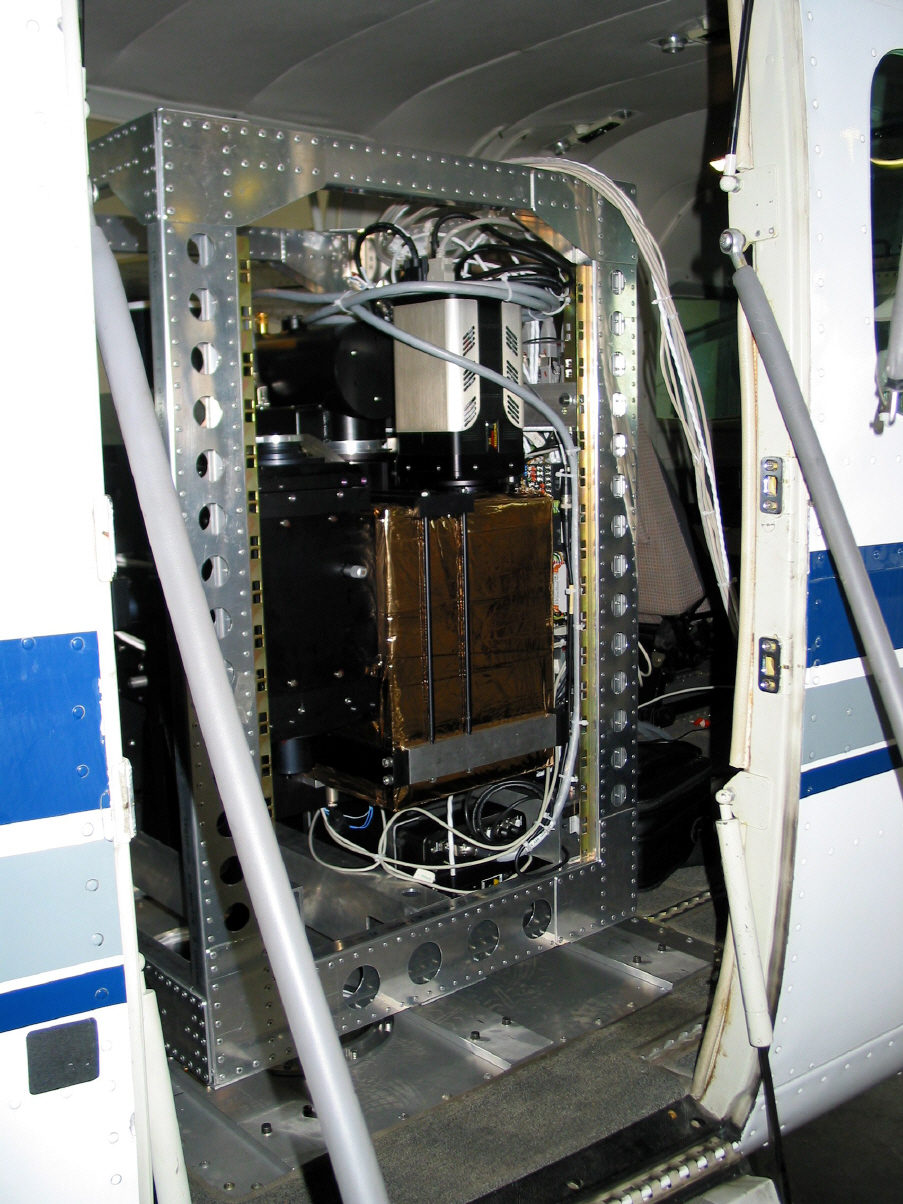
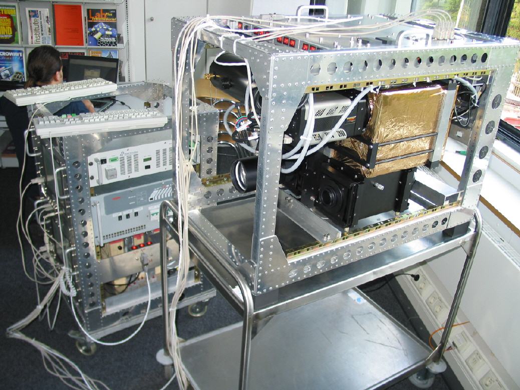
The MAMAP Instrument during "on-ground" testing at the campus of the
University of Bremen.
First on-ground measurements
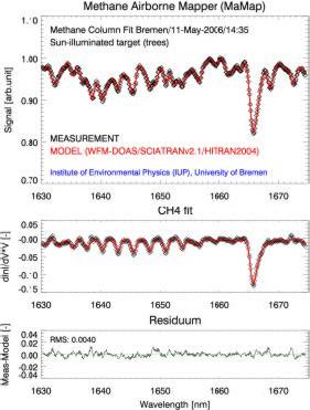
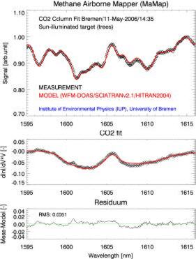
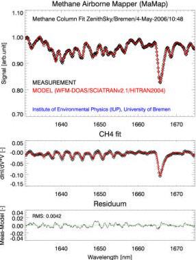
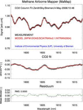
Here we present first preliminary results of atmospheric methane and CO2 MAMAP measurements performed on-ground on the Campus of the University of Bremen. The retrieval algorithm is a modified DOAS algorithm, called WFM-DOAS (Buchwitzet al., 2000), also used for retrieval of methane and CO2 columns from SCIAMACHY nadir observations (Buchwitz et al., 2005, 2006). WFM-DOAS is based on fitting a linearized radiative transfer model to the observed spectra. The fit parameters are scaling factors for the retrieved (partial) columns. For the results shown here the fit parameters correspond to the (total) vertical columns of CH4 and CO2.Figures 2 and 3 show typical CH4 and CO2 spectral fits. The measurement viewing geometry roughly corresponds to a nadir view from an aircraft flying at very low altitude.
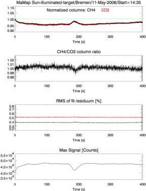
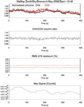
The line-of-sight of the spectrometer has been pointed towards a group of trees located on the Campus of the University of Bremen (“Sun-illuminated target”). The integration time (for a single detector readout) of the measurement was 0.148 s. A very good fit of the spectral absorption features of methane and CO2 has been obtained, as shown in figures 2 and 3. Figure 4 shows the results of a time series ofthese measurements. The bottom panel displays the maximum value of the measured signal, varying due to e.g. clouds and aerosols.
The top panel shows the retrieved normalized CH4 and CO2 columns as a function of time. The columns have been normalized to their profile scaling factor of the first measurement, which is 1.0057 for methane (i.e. the retrieved methane column agrees within 0.57% with the column assumed for the radiative transfer simulations). The second panel shows the ratio of the methane column and the CO2 column which is stable within +/-1%,despite the signal fluctuations due to clouds. Figures 5-7 show similar results as shown in Fig. 2-4 but for zenith sky observations (S/N equivalent to nadir view over low albedo scenes).
Fig. 2: Typical MAMAP methane fit for a
quasi-nadir observation from low altitude
(sun-illuminated target observation).
Fig. 3: As Fig. 2 but for CO2.
Fig. 4: Time series of CH4 and CO2 column measurements for sun-illuminated target
observations.
Fig. 5: Typical MAMAP CH4 fit for a zenith
sky observation from the ground.
Fig. 6: As Fig. 5 but for CO2.
Fig. 7: Time series of CH4 and CO2 column measurements for zenith sky
observations.