|
|
|
|
|
|
|
|
|
|
We are primarily interested in the atmospheric distribution and the (surface) sources and sinks of the atmospheric gases carbon dioxide (CO2), methane (CH4) and carbon monoxide (CO).
Our focus is on satellite data and their interpretation. In particular, we are working on retrieval algorithms to produce scientific and operational data products from satellites (SCIAMACHY, GOSAT, GOSAT-2, OCO-2, S5P, PRISMA, EnMAP, ...) for various applications.
This youtube video presents an overview of what we do as presented by Michael Buchwitz on 18-Feb-2026 in the framework of ESAs Monitoring Climate Change from Space Webinar Series: Satellite Retrievals of CO2 and Methane.
Here another video including inverse modelling related aspects: Webinar from 4-Dec-2025 given by Michael Buchwitz (Univ. Bremen, IUP) and Dominik Brunner (Empa): How satellite-based observations help us monitor GHG emissions.
Another focus are aircraft data (MAMAP) and drones.
We are also working on future satellite missions such as the planned European anthropogenic CO2 monitoring (CO2M) mission, a constellation of satellites (planned launch: 2026/2027) based on our CarbonSat concept. See also CarbonSat Concept from University of Bremen Realized by OHB (or in German: CarbonSat-Konzept der Universität Bremen wird von OHB realisiert) and ESA Realizes University of Bremen CarbonSat Concept (or in German: ESA realisiert CarbonSat-Konzept der Universität Bremen).
The purpose of this web site is to collect and make available all information related to these activities.
We also contribute to or even maintain several other websites:
Here some links to past or internal websites:
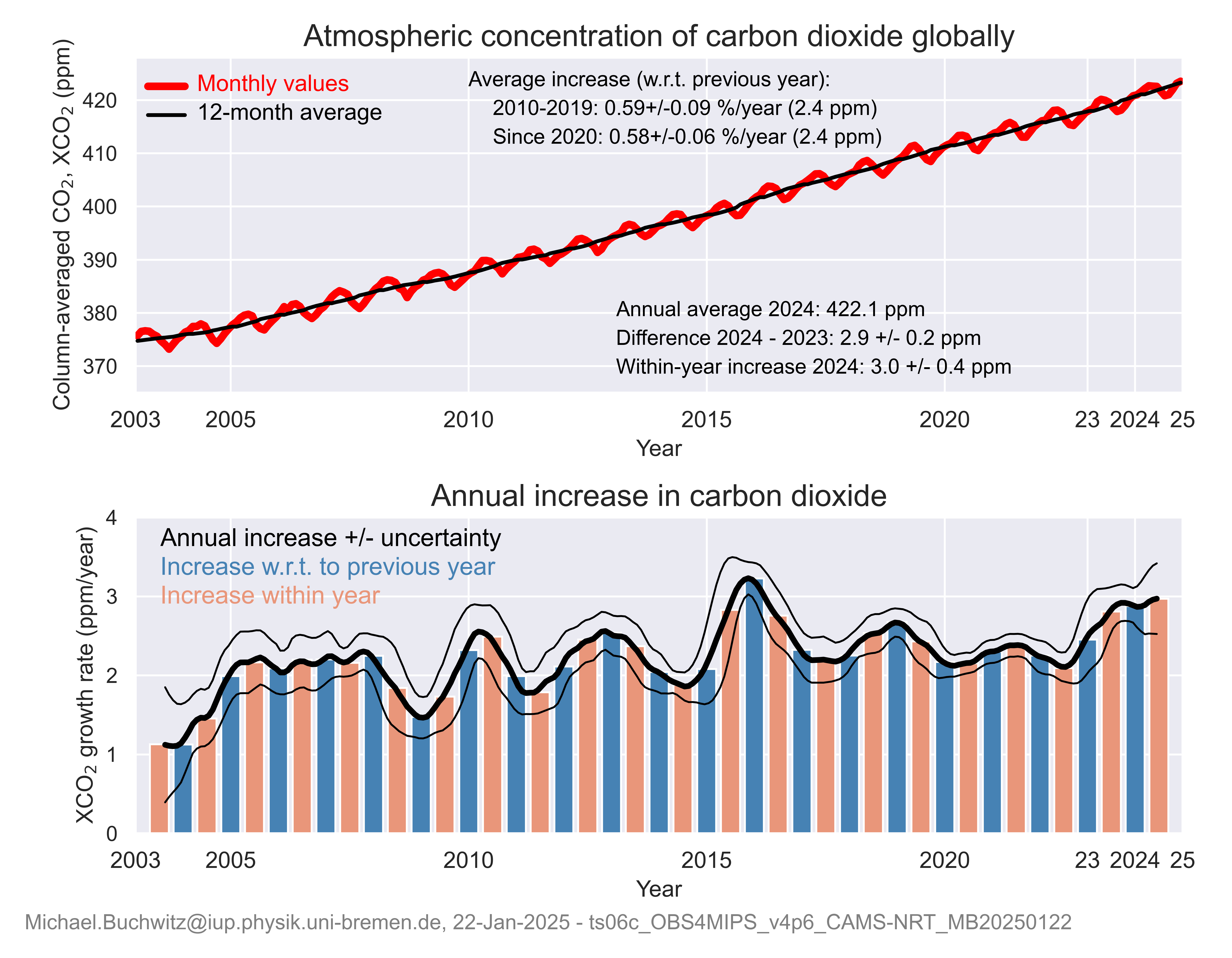
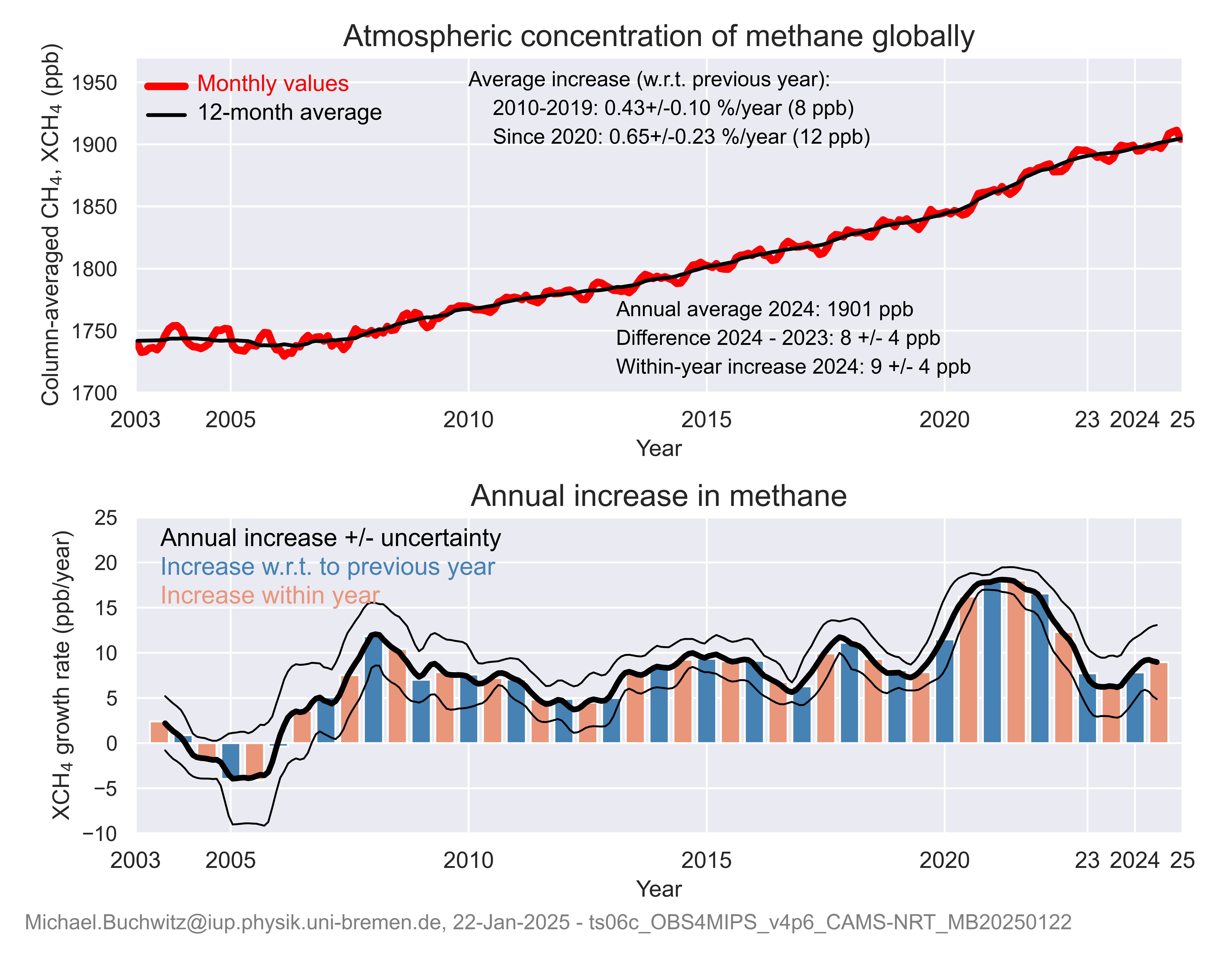
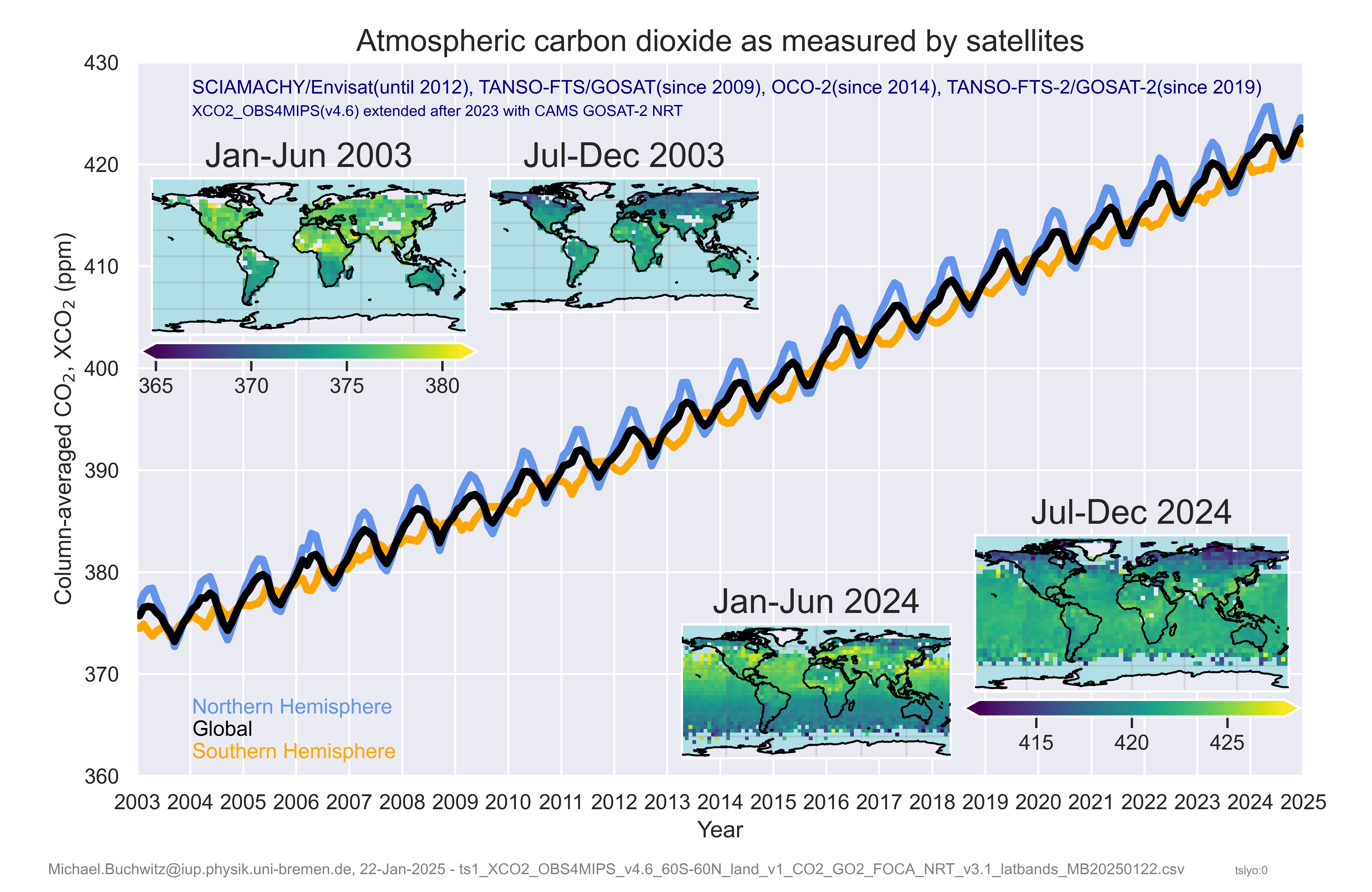
Here some satellite-derived CO2 and methane time series and growth rates (the underlying data have also been used for the Climate Indicators section of the Copernicus / WMO European State of the Climate (ESOTC) 2024 report):
Satellite-derived monthly column-averaged CO2 (XCO2) (top) and corresponding annual growth rates (bottom):
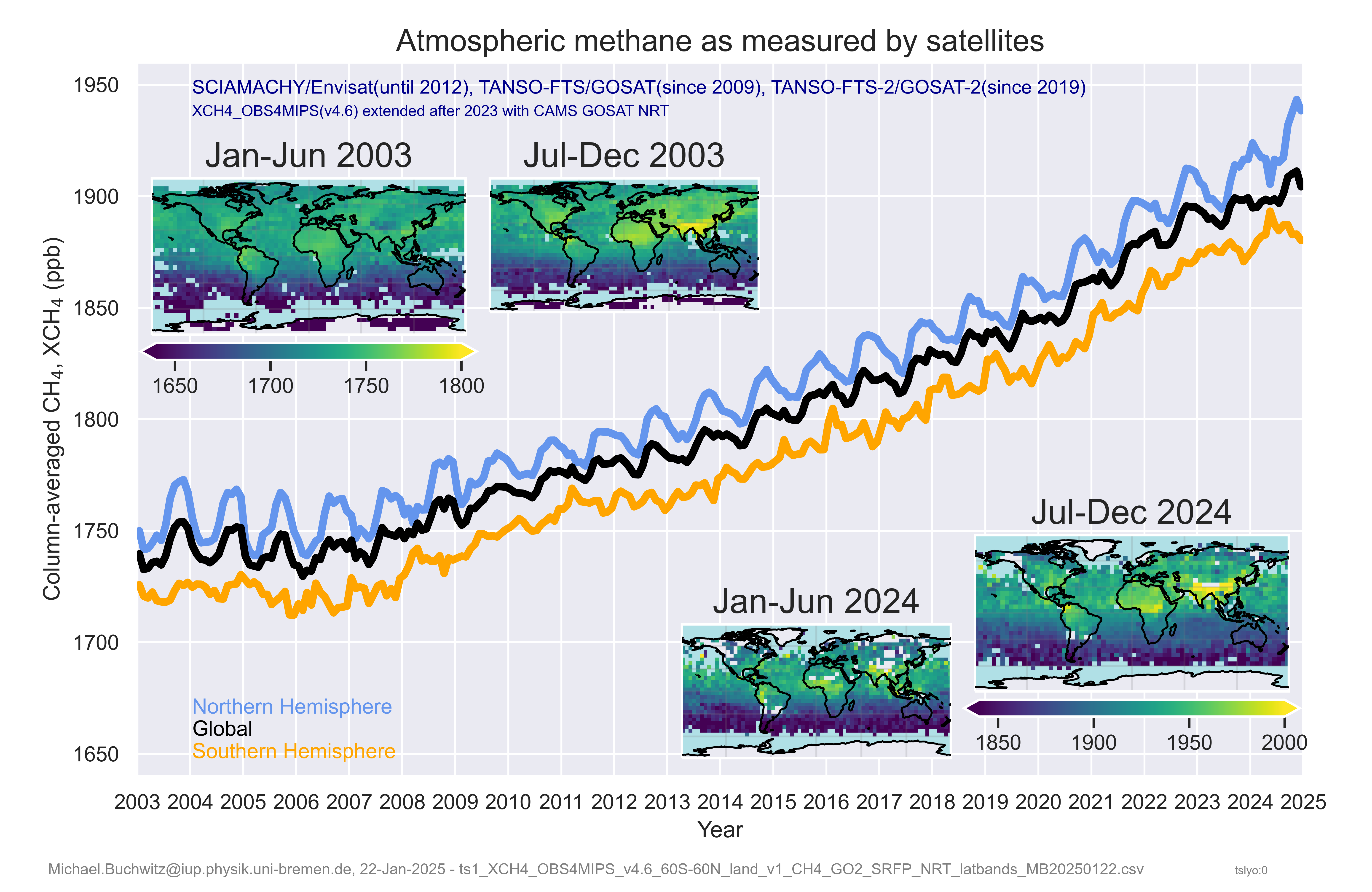
Satellite-derived monthly column-averaged methane (XCH4) (top) and corresponding annual growth rates (bottom):
Timeseries and maps of satellite-derived XCO2 retrieved from SCIAMACHY (until 2012), GOSAT (since 2009), OCO-2 (since 2014) and GOSAT-2 (since 2019) radiance spectra. As can be seen, atmospheric CO2 concentrations are increasing despite world-wide efforts to reduce fossil fuel related CO2 emissions.
Timeseries and maps of satellite-derived XCH4 retrieved from SCIAMACHY (until 2012), GOSAT (since 2009) and GOSAT-2 (since 2019) radiance spectra. As can be seen, atmospheric CH4 concentrations are increasing since 2007.
A global map of satellite-derived XCH4 retrieved from TROPOMI onboard the Sentinel-5-Presursor (S5P) satellite. The underlying data can be otained from the University of Bremen TROPOMI/S5P WFMD website as Level 2 (non-gridded) product. The data have been generated using a retrieval algorithm developed in the framework of the ESA GHG-CCI project:
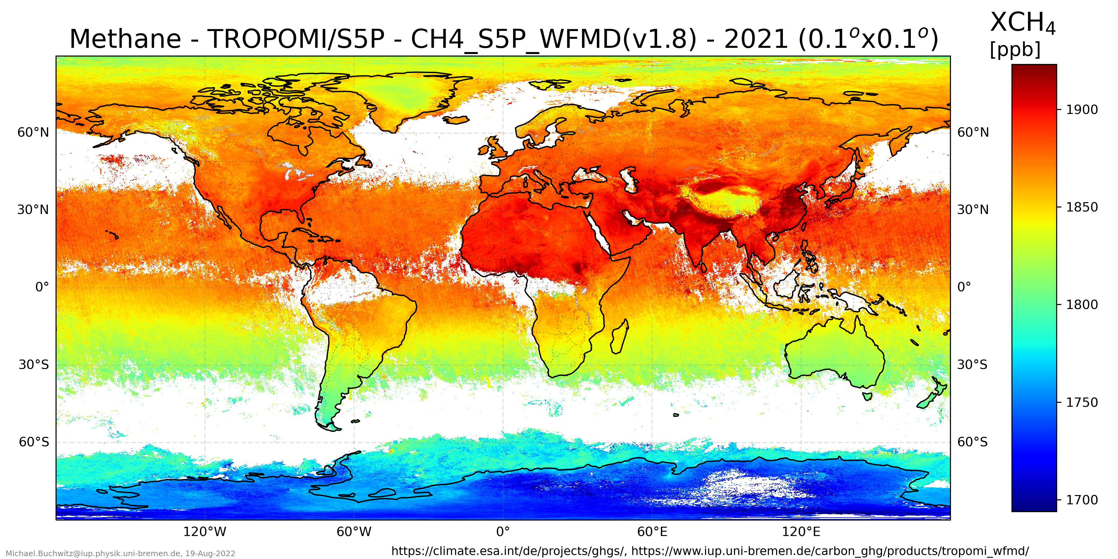
The figure is also available as GeoTIFF file.
Last modification: 10-March-2026
Author: Michael.Buchwitz@iup.physik.uni-bremen.de