|
|
|
|
|
|
|
|
|
|
Below we provide access to satellite-derived CO2 and CH4 data products and related documents as generated via several projects:
The growth rates are regularly updated, e.g., in the context of our Copernicus activities, see:
Copernicus/WMO ESOTC 2024 report and corresponding press release (15.04.2025): European State of the Climate 2024 report (https://climate.copernicus.eu/esotc/2024) with IUP, University of Bremen, contributions with satellite-derived CO2 and methane data sets for the Climate Indicators section (https://climate.copernicus.eu/esotc/2024/trends-climate-indicators).
Copernicus Press Release (10-Jan-2023) with CO2 and CH4 from Univ. Bremen: Copernicus: 2022 was a year of climate extremes, with record high temperatures and rising concentrations of greenhouse gases.
See also our contribution to Copernicus European State of the Climate 2021 (22-Apr-2022) with CO2 and CH4 from Univ. Bremen: ESOTC 2021. Satellite-derived greenhouse gas concentrations from Univ. Bremen: Climate indicators: Greenhouse gas concentrations.
These data sets are called "Climate Data Records" (CDR) and each year we extend the existing time series by one year (either by adding one year or by reprocessing the entire time series for a given product including the added year).
Here we provide links to the relevant documentation:
The CDR8 data products are Level 3 products (in Obs4MIPs format) and available via the Copernicus Climate Data Store (CDS). There are 2 type of products: Column-averaged mixing ratios (XCO2 and XCH4) obtained from combining data from several satellite sensors and mid-tropospheric (MT) mixing ratio products from the IASI instrument series. The documentation is available online via the CDS. Here we provide corresponding pdfs (obtained with a print option):
The data products are available via the Copernicus Climate Data Store (CDS). Documentation:
The data products are available via the Copernicus Climate Data Store (CDS). Documentation:
The data products are available via the Copernicus Climate Data Store (CDS). Documentation:
The data products are available via the Copernicus Climate Data Store (CDS). Documentation:
The data products are available via the Copernicus Climate Data Store (CDS). Documentation:
The data products are available via the Copernicus Climate Data Store (CDS). Documentation:
The data products are available via the Copernicus Climate Data Store (CDS). Documentation:
These data sets are called "Climate Research Data Package" (CRDP) and each year we make an updated data set available.
Here we provide links to the relevant documentation (most of these documents are also available from the GHG CCI key-documents website):
The 4C project is funded by the European Union's Horizon 2020 research and innovation program under Grant Agreement No. 821003.
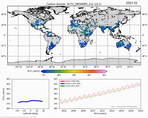
For this project, we generate a specific data product from satellites: XCO2 (in ppm), i.e., column-averaged dry-air CO2 mole fractions, including uncertainty estimates, averaging kernels, etc.
The product is a gridded (Level 3) product in Obs4MIPs format and has monthly time and 2 deg x 2 deg spatial resolution.
How a similar product but with lower spatial resolution (5 deg x 5 deg) has been generated is described in detail in Reuter et al., 2020. The latest version of that CO2 product is available via the Copernicus Climate Data Store (CDS) (simply search for CO2).
The latest product generated for 4C is XCO2_OBS4MIPS_2x2, version 4.2. This product covers the period 2003 - 2019.
For information on this product, including validation, please read this DESCRIPTION (pdf file) (or the similar but differently formatted D1.5 (pdf file) deliverable document).
Data download: ACCESS to DATA PRODUCT (single NetCDF file, 310 MB) For data usage conditions please see Section 7 of the DESCRIPTION.
How this product "looks like" is shown in this ANIMATION (gif, 15 MB).
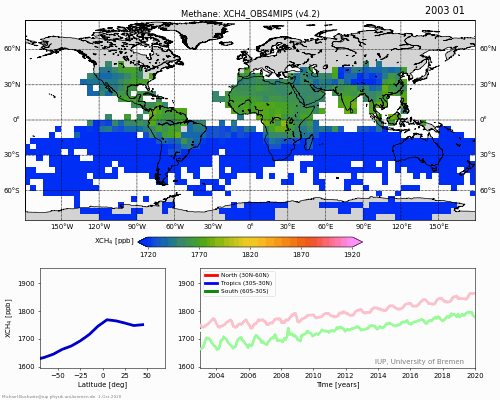
We also generated a similar data product for XCH4 (column-averaged methane, see also Reuter et al., 2020). For access to this data product please click HERE. For data usage conditions please see Section 7 of the DESCRIPTION. To see an animation (currently only for 5 deg resolution) please click HERE.
Here information related to the latest update of our product (v4.5; 2003-2022) as generated for 4C:
For access to this v4.5 data product please click HERE (NetCDF, 365 MB).
For additional information including data usage conditions of the v4.5 product please see Section 2.7 of this Technical Report (pdf).
Last modification: 20-Nov-2025
Author: Michael.Buchwitz@iup.physik.uni-bremen.de