You are here: Home » instrument » Modes

SCIAMACHY Measurement Modes

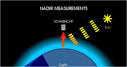
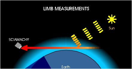
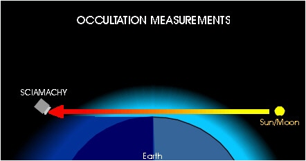
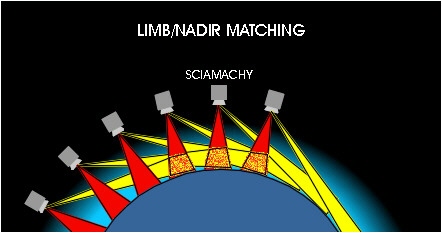
  • SCIAMACHY measures in three viewing geometries: Nadir, Limb, and Occultation.
Nadir Geometry
Nadir Geometry In Nadir mode the atmospheric volume directly under the instrument (i.e. the spacecraft) is observed. Each scan covers an area on the ground of up to 960 km across track with a maximum resolution of 26 km x 15 km.
Limb Geometry
Limb Geometry In Limb mode the instrument looks at the edge of the atmosphere. Scans at different tangent altitudes over a range of up to 960 km in horizontal direction are performed with a geometrical vertical resolution of approximately 2.6 km.
Occultation measurements
Occultation measurements are performed using the same geometry as in Limb mode, but with the sun or the moon in the instrument's field of view. Atmospheric densities are obtained by comparing measurements of the transmitted solar or lunar radiation with the unattenuated source. Solar occultation measurements are performed regularly during sunrise (latitude range 90° N - 65° N). Lunar occultation measurements during moonrise (between 30°S - 90°S) - which are possible for about one week per month - are used for process studies.
Limb / Nadir Matching
Limb / Nadir Matching One of the most important features of SCIAMACHY is the possibility to observe the same atmospheric volume first in limb and then after about 7 minutes in nadir geometry. By using this Limb/Nadir matching three-dimensional information about the atmosphere can be obtained.
  • Global Coverage
  • With its orbital period of about 100 minutes, SCIAMACHY is able to observe the whole Earth. Global coverage at the equator is achieved within 6 days when using the standard alternating Limb/Nadir scan option. Using only Nadir or Limb modes global coverage is achieved within 3 days (for 960 km swath width).
  • Because of the "dynamics scan mode" global coverage goes in line with a rather "local" spatial resolution for PMD measurements and special wavelength ranges. Therefore, the vertical profiles of temperature and several long-lived trace constituents are measured at high spatial resolution.
  • Details on the SCIAMACHY instrument operations concept can be found at the SOST Website.
    Geometrical FOV Coverage Typ. Spatial Resolution
Nadir along track 25 km continuous 30 km
  across track 0.6 km +/- 480 km 60 km
Limb azimuth 110 km* +/-460 km* 250 km*
  elevation 2.5 km* 0 - 200 km* 3 km*
Solar Occultation azimuth 40 km* N.A. 30 km*
  elevation 2.5 km* 0 - 200 km* 2,5 km*
    * at tangent point