

2014 - 2015
December 2015
University of Bremen, 2. Dezember 2015
European Commission’s Experts recommend University of Bremen’s concept for quantifying greenhouse gas emissions from space
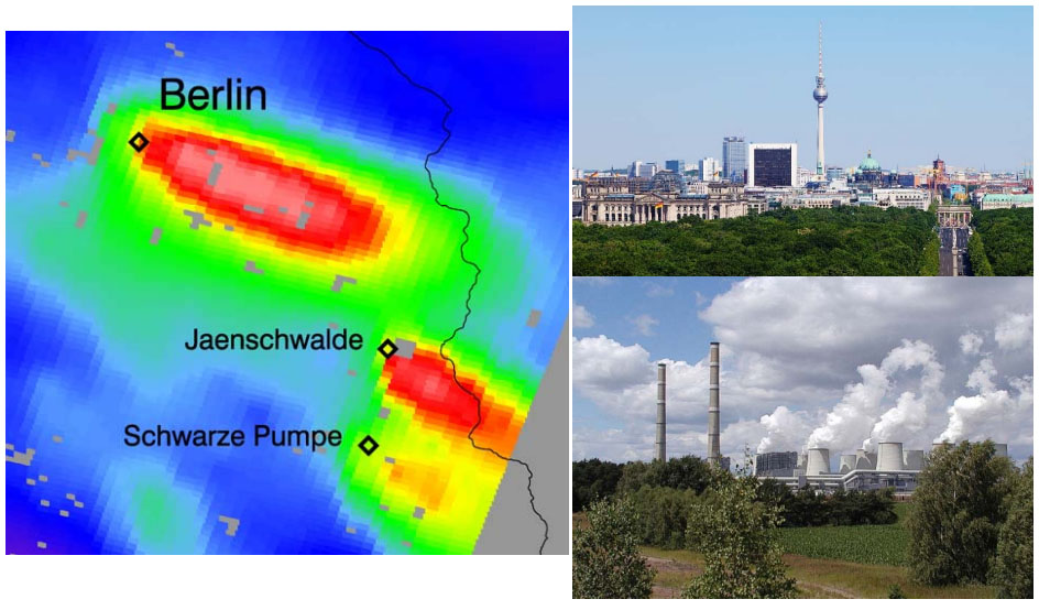
The European Union Copernicus Climate Change Service recently identified the lack of an operational monitoring system for man-made CO2 emissions. This is of major relevance for the upcoming climate conference of the UN Framework Convention on Climate Change in Paris in December. A group of external experts brought together by the European commission was asked to assess the need and opportunity for an independent European space-borne CO2 observational capacity to monitor and verify the compliance of parties to international climate agreements. Their report was released recently (see web link) and presented in Brussels in November. The expert group identified the space and ground segment required to deliver surface emissions for monitoring and treaty verification purposes. The report proposes and recommends a concept similar to the CarbonSat concept which was developed and published by researchers at the Institute of Environmental Physics of the University of Bremen. This concept uses the imaging of greenhouse gas “plumes” observed from space to determine the emissions from cities and strong local point sources. The concept builds on the success of a previous Bremen instrument called SCIAMACHY, which flew on ENVISAT 2002 to 2012 and made the first measurements of the atmospheric loading of CO2and CH4but at low spatial resolution. The high spatial resolution concept has been demonstrated by researchers of the University of Bremen using airborne measurements.
In two events in November the European vision of an operational CO2 monitoring concept was presented first to members of the European parliament and then to the Copernicus User Forum. The required space segment for CO2monitoring will yield accurate, transparent and consistent quantification of fossil CO2 emissions and their trends at the spatial scale of megacities, important industrial sites, small regions, countries, and the Earth as a whole. This capability would provide Europe with a unique and independent source of actionable information for all stages of the policy cycle. Furthermore, the data from a CarbonSat-type mission provides an objective independent contribution to a future international global carbon observing system. The researchers of the Institute of Environmental Physics of the University of Bremen are well prepared to contribute to the implementation of the CarbonSat concept.
Discussions will be held between ESA and the European Commission to investigate flying a Carbon Monitoring satellite within the EU Copernicus Sentinel programme – the suite of satellite sensors being launched by Europe to routinely observe the Earth. It is probable that ESA, whereas not selecting CarbonSat as Earth Explorer, will ask its member states at the agency's next ministerial meeting end of 2016 to fund a Carbon Monitoring prototype satellite to allow Europe for an independent view on CO2 emissions.
In conclusion, the global monitoring of CO2 emissions by a “CarbonSat type” system is accepted and the issue is now the political will to develop this important system.
Web-Links European Commission, COPERNICUS
http://www.copernicus.eu/main/towards-european-operational-observing-system-monitor-fossil-co2-emissions
WWW-Link CarbonSat@Universität Bremen
http://www.iup.uni-bremen.de/carbonsat/
WWW-Link: MAMAP@Universität Bremen:
http://www.iup.uni-bremen.de/optronics/projects/methaneairbornemappermamap/index.htm
Contact:
Institut für Umweltphysik
Universität Bremen
http://www.iup.uni-bremen.de
Prof. Dr. John P. Burrows
Fon: 0421 218 62100
E-Mail: burrows@iup.physik.uni-bremen.de
Dr. Heinrich Bovensmann
Fon: 0421 218 62102
E-Mail: heinrich.bovensmann@uni-bremen.de
October 2015
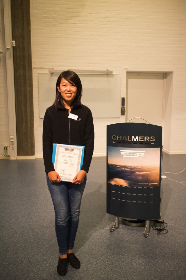
Young Scientist Jia Jia wins “Best Poster” at Atmospheric Limb Workshop
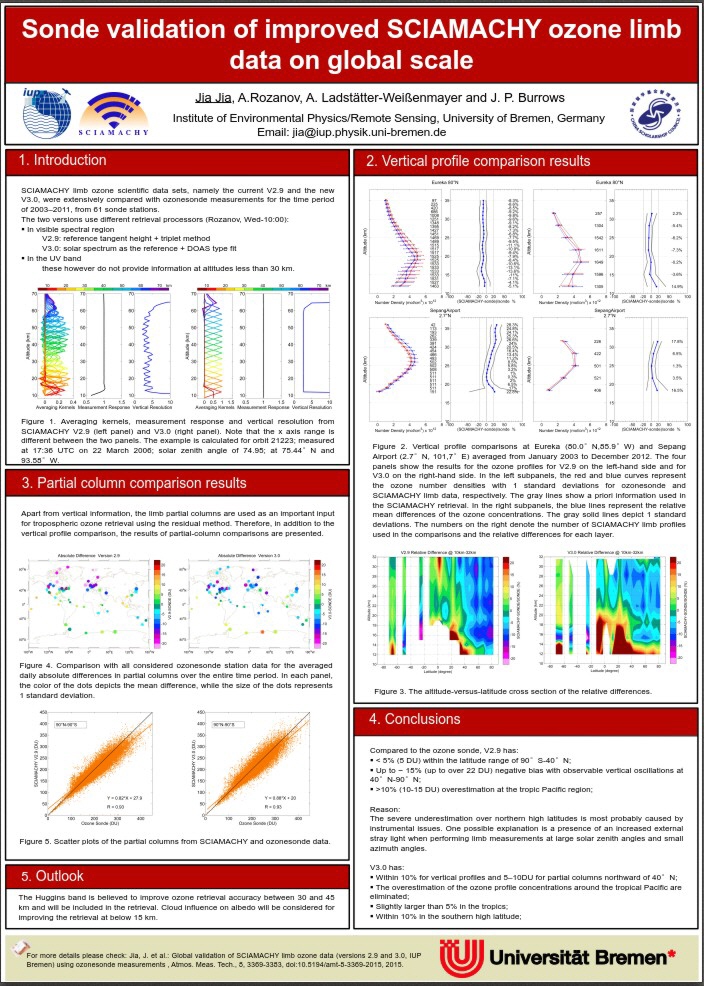
The Atmospheric Limb Workshop is a biennialevent involving more than 8 countries. The scientific focuses are theLimbmeasurements: Emission (UV, visible, IR, microwave), occultation (solar, stellar, lunar), scattering; past, current and future space-borne instruments: SMR, OSIRIS, ACE, GOMOS, MIPAS, SCIAMACHY, SMILES, SAGE, SABER, MLS, SOFIE, HIRDLS, OMPS, ALTIUS, MATS, STEAM; observations and modellingatMesosphere and above, stratosphere, UTLS and troposphere; retrieval algorithms and data assimilation; radiative transfer and spectroscopy. This year it took place from 15 to 17 September in Chalmers University of technology in Gothenburg, Sweden. Like many scientific events, a young scientist award is set for best oral and poster presentations among the PhD student and early stage postdocs. 25 candidates participated in the poster competition. These candidates come from 14 institutes and universities (e.g., JPL, NASA, KIT, NICT, University of Saskatchewan) from 6 countries - Canada, Germany, US, Sweden, Japan, and India. Jia Jia in our institute participated in the competition and won the best poster.
Jia comes from Shandong province in China. She joined IUP in October 2011 to optimize the SCIAMACHY Limb Nadir Matching method in tropospheric ozone retrieval with the funding from CSC (China Scholarship Council) scholarship. The tropospheric ozone monthly data is well improved with the benefitof the V3.0 limb ozone profile information. In this Limb Workshop, she showed the ozonesonde validation of improved SCIAMACHY limb ozone data on a global scale. The newly developedV3.0 limb dataset has a better agreement with ozonesonde in both vertical structure and partial column, especially in the Northern high latitudes. This work is also published in AMT.
Links:
Publication: http://www.atmos-meas-tech.net/8/3369/2015/amt-8-3369-2015.html
website: http://www.chalmers.se/en/conference/limb-workshop-2015/Pages/default.aspx
September 2015:
European and Chinese Scientists meet to assess and discuss Atmospheric
Pollution in Europe and China:
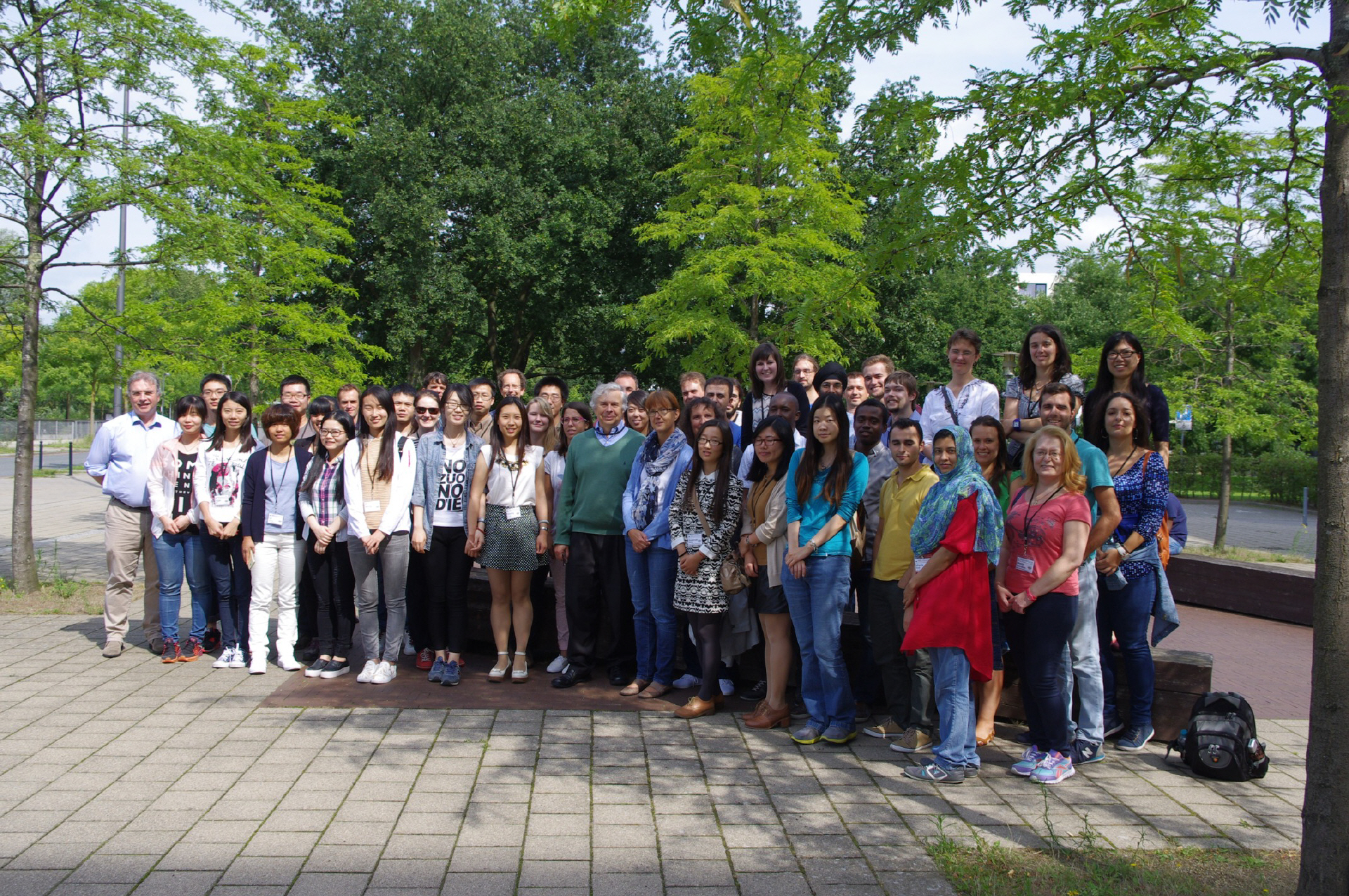
The PANDA Marco Polo summer school on Atmospheric Pollution at the Institute of Environmental Physics, University of Bremen23rd –30th August 2015
Recently, the World Health Organization (WHO) reported that one out of eight of
global deaths worldwide is caused by air pollution. The strong economic growth in
China over the past three decades has led to China being the largest emitter of
greenhouse gases. Also, serious regional air quality problems are now found in its
many mega cities, e.g., in Beijing, Shanghai and Hong Kong. At the same time and
as a result of large efforts made over the last three decades, mitigation measures in
industrial production practices and the development of strict legislation have led to
improved air quality in many regions of Europe and the USA. China, in particular, is
faced with the difficult problem of maintaining rapid economic growth whilst reducing
air pollution and improving quality of life. To tackle this problem, much more
quantitative information about the amounts and distribution of pollutants and a better
understating of the smog formation mechanisms are therefore needed to facilitate the
reduction of health threatening emissions from human activities while promoting the
most effective and sustained economic development.
Satellite observations provide an exciting, relatively novel tool for the attribution and
prediction of air quality and for monitoring the dispersion of air pollution. The
Institute of Remote Sensing / Institute of Environmental Physics led by
Professor John P. Burrows has pioneered the measurement of atmospheric
pollution from space-based instrumentation over the last 30 years, working together
with the leading atmospheric modelling and prediction groups. The PANDA
(PArtnership with chiNa on space DAta) project, supported by the European
Commission, is a consortium of 7 European laboratories and 7 Chinese research
groups. It provides the evidence base from measurements and modelling to improve
our knowledge on the formation and fate of air pollution required for the development
of adequate environmental policies for clean air and sustainable development.
PANDA is led by Prof. Guy Brasseur from Max Planck Institute of Meteorology
Hamburg, and comprises scientific partners from Universities and research
centres in Europe and China.
As part of PANDA and its European sister project Marco Polo, more than 40 early
career scientists, primarily from China and Europe, participated in a summer
research school from the 23rd to the 30th August, 2015, at the Institute of
Environmental Physics of the University of Bremen. The latest research results from
space-based remote sensing and atmospheric modelling together with the
interpretation of observations were central themes of the summer school. The topics
ranged from the fundamentals of remote sensing and atmospheric modelling to the
estimation of anthropogenic emissions and the impact of economic development and
legislation on air quality. The objective of this summer school and its counterpart
which will be held next year in Chain is to reinforce cooperation between scientists of
China and Europe to jointly address complex questions related to air pollution, and
climate change.
Link: Meeting Programme
August 2015:
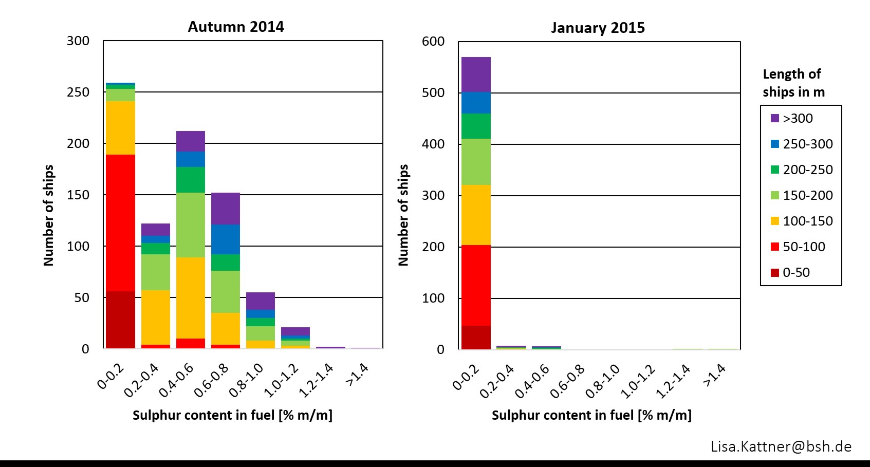
This picture shows the change in sulphur content in ship fuels. Before the regulation change on January 1st2015, ships were allowed to use fuels with 1% sulphur content, since this date only much cleaner fuel with 0.1 % is allowed. Data was obtained by measuring exhaust gases of ships with in-situ instruments from a land-based measurement station in Wedel near Hamburg at the Elbe River. This method allows a monitoring for compliance of a large number of ships without having to enter the ships and take fuel samples. Within about 3 months of collecting data, 1413 ships could be analysed for their fuel sulphur content and 95 % of all ships analysed in January comply with the new, much stricter regulations. The measurements were carried out within the project “MeSmarT”, a cooperation between the IUP, Bremen, and the Bundesamt für Seeschifffahrt und Hydrographie, Hamburg.
Links:
Publication:http://www.atmos-chem-phys-discuss.net/15/11031/2015/acpd-15-11031-2015.html
Press release: http://www.iup.uni-bremen.de/deu/downloads/wittrock---150206marpol_vi_jahreswechsel_14_15.pdf
Website:http://www.mesmart.de/
April 2015:
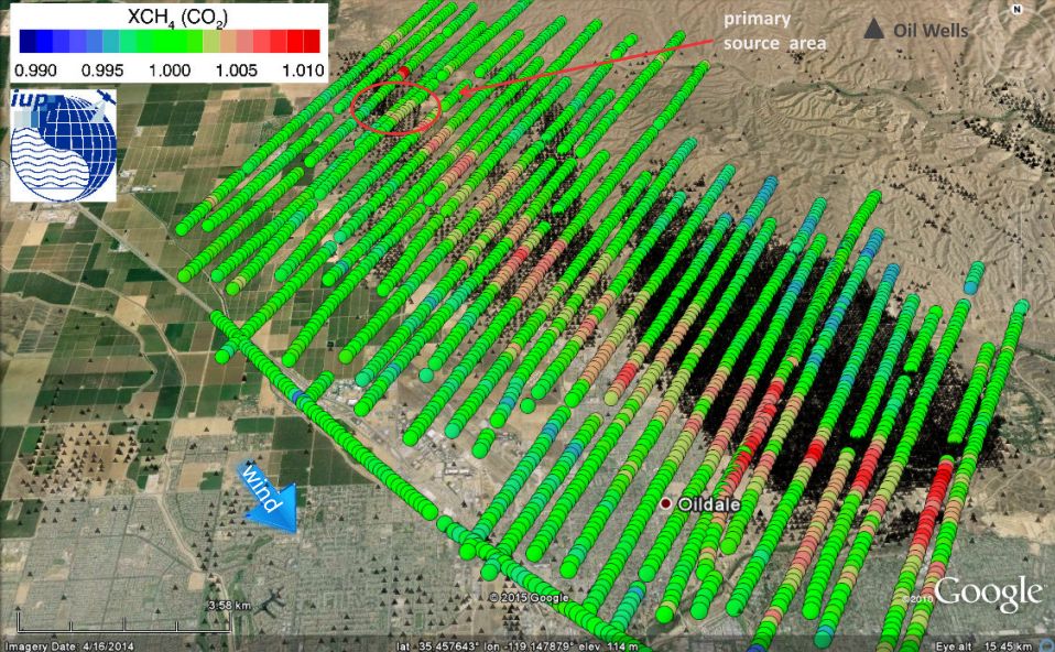
First detection of a large scale methane plume extending several kilometers over a southern
California Oil Field using passive airborne remote sensing. The measurement was performed on
September 04, 2014 with the MAMAP sensor developed at the Institute of Environmental Physics –
IUP.
The data was acquired in summer 2014 during the COMEX-Campaign, a jointly funded ESA and NASA
project. The European MAMAP remote sensing sensor developed and operated by the Institute of
Environmental Physics at the University of Bremen in cooperation with the German Research Centre
for Geosciences (GFZ) was installed on a Twin Otter aircraft operated by the Center for
Interdisciplinary Remotely-Piloted Aircraft Studies CIRPAS. The instrument detected during several
flights unexpectedly large methane plumes over an Oil field in southern California, which could be
traced over a distance of several kilometers. These measurements demonstrate for the first time
that strong local methane emissions from Gas and Oil production could be detected by passive
remote sensing and traced in space. The data will be used to estimate the magnitude of the emissions resulting from such facilities.
See also press release of the University of Bremen :
Additional pictures are available at:
http://www.iup.uni-bremen.de/optronics/downloads/COMEX%20Release%20Oil_Field_final_v3_short_de_Pictures_Only.pdf
February 2015
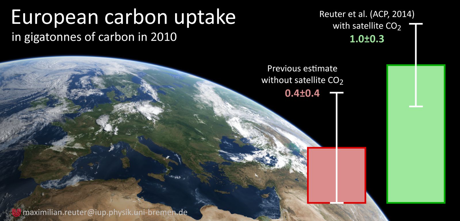
This image was featured by ESA in a web-story entitled “Is Europe an underestimated sink for carbon dioxide?”
http://www.esa.int/Our_Activities/Observing_the_Earth/Is_Europe_an_underestimated_sink_for_carbon_dioxide
A new study using satellite data suggests that Europe’s vegetation extracts more carbon from the atmosphere than previously thought. The complete study authored by Maximilian Reuter et al. was published recently in Atmospheric Chemistry and Physics.
http://www.atmos-chem-phys.net/14/13739/2014/acp-14-13739-2014.html
December 2014
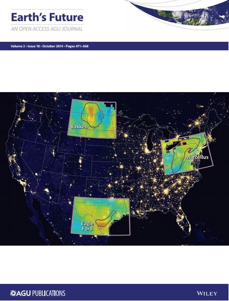
This cover picture was published recently in the AGU journal Earth's Future (http://onlinelibrary.wiley.com/doi/10.1002/2014EF000265/abstract).
The composite image comprises the following:
a) the night-time image of light coming from the earth, using data acquired by the Visible Infra-red Imaging Radiometer Suite on-board the Suomi NPP satellite in 2012, and
b) an overlay showing the changes in the methane over the continuously growing oil and gas production regions Bakken, Eagle Ford, and Marcellus. The latter is the difference in column methane between the periods 2006-2008 and 2009-2011 and has been derived from measurements made by the SCanning Imaging Absorption spectroMeter for Atmospheric CHartographY (SCIAMACHY) satellite instrument. (Night-time lights background NASA / overlay by O. Schneising). SCIAMACHY flies on the ESA Envisat and downlinked measurements from 2002 to 2012 when Envisat failed.
The complete study is published in "Remote sensing of fugitive methane emissions from oil and gas production in North American tight geologic formations"; EARTH'S FUTURE Volume 2, Issue 10, October 2014, Pages: 548–558, Oliver Schneising, John P. Burrows, Russell R. Dickerson, Michael Buchwitz, Maximilian Reuter and Heinrich Bovensmann; Article first published online : 6 OCT 2014, DOI: 10.1002/2014EF000265